article-1208038-06212B30000005DC-264_306x423-777174
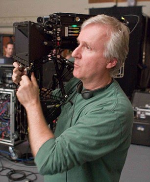
Titanic director; James Cameron gets ready to unveil his long-awaited sci-fi adventure “Avatar.” While I admittedly hadn’t closely followed what he’s been up to recently, an article in Wired magazine quickly peaked my interest. Wired takes a looks at the filmmaker and the technological achievements that helped him bring his stunning 3-D Avatar to the big screen. There was a lot of vision & patience that went into the creation of Avatar, and technological advancements that needed to happen before the movie could really be made. I for one respect his passion and patience and will do my part to help ensure that this movie earns at least the 250 million that it needs to in order to be profitable.

Link: Wired Magazine: James Cameron’s Epic Quest for Avatar

Link: James Cameron Stereoscopic 3D camera


If you weren’t already aware I bought a boat last month. It’s probably a large part of the reason I haven’t made many blog posts recently. It’s been great & even though I didn’t have the boat in the water & ready to sail until late July, I’ve still gotten in some great evenings & weekends. Now however we’re in hurricane season. Now I get nervous each time I see or hear the word “hurricane” on the news. It didn’t seem like we got this many hurricanes last year, (1 in fact, which ended up being a tropical Depression by the time it hit) but now that I bought a boat it’s like every weekend. In any event I thought I’d throw together a list of resources that help track hurricanes & predict their paths. I’m certainly hoping that this storm (Danny) goes out to sea!

Link: IbisEye – Atlantic Hurricane Tracking 1850 – Present.
Link: StormPulse – Tropical Storm tracking, including “”cone of uncertainty.”
Link: Tropical Atlantic – National Hurricane Center model data (“Spaghetti Plots.”)

As summer begins winding to a close, hurricane season is just getting started. The folks at the Sarasota Herald Tribune have created a sweet map and data mashup for tracking hurricanes at Ibiseye.com. It uses Google Earth imagery and maps. You can even choose to overlay it with the latest satellite image. You can track Fay, or any other storm in the archives. All of the current weather advisories from NOAA are on the site as well. In addition to hurricanes and tropical storms, this site also keeps track of all current weather advisories like flood warnings, heat advisories, thunderstorms, etc.

The site gained it’s namesake from the Ibis, which is said to be the last bird to leave ahead of a storm and first to return; ibisEYE.com gives a similar view of all hurricanes to hit Florida from 1851 to today.

Read more

Lately I’ve been doing rather large events over the weekend where lots of pictures are taken. So what I’ve been doing is getting pictures from everyone present, sorting them by time taken, then putting them into one album. I find that one tool that works great for this is Google’s “Picasa.” Picasa is a great photo management tool that displays your photos chronologically and even offers some basic fixes to your photos. Photoshop is great for editing photos too, but when you’re working with over a hundred photos, something quick and easy is best. Perhaps Picasa’s best feature is it’s auto resizing. If I tried to send someone a dozen pictures the email would be huge. Picasa resizes them down to a manageable size enabling me to email lots of photos to people with only the click of a button. It’s prety cool. The program is free and I’d definitely recommenced checking it out.

I took some photos from Washington DC and the weekend of the 4th, and that’s how I post all that stuff. Check it out here. If you were there, and you haven’t sent me your pictures yet; get with it and send them to me. Picasa makes it simple.

Link: Download Picasa
Link: Some Pictures From July

A lot of times I release a new part of this website which is mostly just for me, but could also be handy to others. I have worked on a couple pages like this lately, one of which is my Surf Page. It’s pretty bare at the moment, and not linked from anywhere but here, but I do have plans to incorporate a lot of the board sports I do in a more prominent way. The Surf Page is pretty much just a reference page for me so that I can see the surf and check the reports in the Southeastern Massachusetts area, but if you’re a surfer from the area, or feel like following it, this page should be a good starting point. I’ll post a little information about some of the other pages I’ve made ion the near future.

Link: EricDresser.com :: Surf Page

Google earth might possibly be my favorite program on the internet. For all that it does it receives not nearly enough praise. It is possible to spend an entire day jumping from place to place and exploring almost as if you are on vacation there. What a cool program. You would think that once you released Google Earth there’s not much more you could add. Sure enough there are tons and tons of add ons that are available in the newer versions of the program. You can see points of interest, snapshots taken around a particular point, and even outlines of park boundaries. There’s even ways to import files into Google earth so outside interests can you Google Earth’s interface in displaying locations (such as is the case in geocaching.)

In the most recent version of Google Earth there are two notable big additions to the program. One being Sky view, and the other the hidden flight simulator. Sky view mode is impressive and awesome, but what really stole my attention was the flight simulator. Flight simulator mode is a hidden feature so it can only be accessed by pressing Ctrl + Alt + A (Command + Option + A on the Mac.) Once you have the flight simulator open you can fly anywhere in the world. if you’ve every played a flight simulator before you’ll notice that the controls are very smiler. Check it out, it’s a ton of fun, and can also be quite challenging. If you don’t have Google Earth yet, get it! If you have it already, update! this is one of the coolest things I’ve played with yet especially in the realm of cartography.

Link: More information on the Google Earth Flight Simulator